
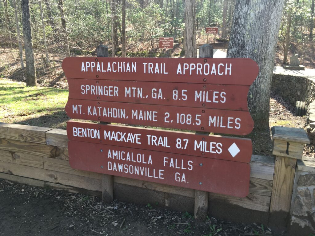
The Appalachian Trail (AT) is a 2,190-mile long hiking trail that traverses 14 states in the eastern United States, from Springer Mountain in Georgia to Mount Katahdin in Maine. Georgia is home to the southernmost section of the AT, spanning approximately 79 miles. This beautiful and rugged stretch of the trail offers hikers a taste of what the entire AT experience has to offer. In this blog post, we will explore the trail towns and highlights of hiking the Appalachian Trail in Georgia.
Springer Mountain: The Southern Terminus
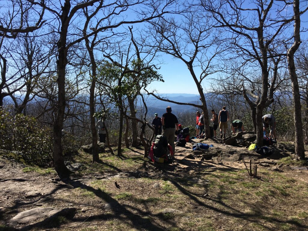
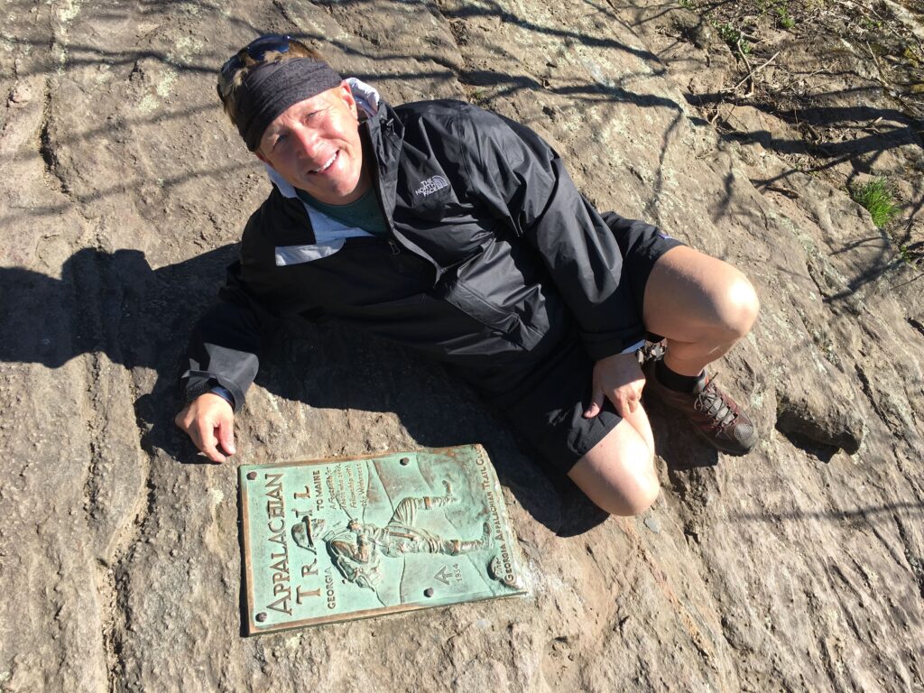
The journey begins at Springer Mountain, the southern terminus of the Appalachian Trail. At 3,780 feet, this peak is the highest point in Fannin County and offers breathtaking views of the surrounding Blue Ridge Mountains. The trailhead is accessible from Forest Service Road 42, which is a gravel road that can be reached from both Ellijay and Dahlonega. There is a parking lot near the trailhead, as well as a small wooden shelter where hikers can sign the trail register and begin their AT adventure.
Hike Inn: A Unique Lodging Experience
Just five miles into the Georgia section of the AT, hikers will come across a side trail leading to the Len Foote Hike Inn. This eco-friendly lodge offers a unique lodging experience for hikers and can only be reached by foot. The Hike Inn provides comfortable accommodations, delicious family-style meals, and educational programs in a beautiful, sustainable setting. Reservations are required, so make sure to book your stay in advance.
Neel Gap and Mountain Crossings: A Hiker’s Haven
At mile 30.7 of the Appalachian Trail, hikers will reach Neel Gap, a significant milestone in their journey. Neel Gap is home to the historic stone building known as Walasi-Yi, which houses the Mountain Crossings outfitter and hostel. This establishment is an essential resupply point and offers gear, food, and advice for hikers. Mountain Crossings is also the only place on the entire AT where the trail passes through a man-made structure. The hostel is a popular spot for hikers to rest, socialize, and share stories of their adventures.
Blood Mountain: The Highest Peak on the Georgia AT
Blood Mountain, standing at 4,458 feet, is the highest peak on the Georgia section of the Appalachian Trail. The climb to the summit can be challenging, but the panoramic views from the top are well worth the effort. On a clear day, hikers can see the Blue Ridge Mountains stretch out in all directions, with rolling hills and lush forests as far as the eye can see. The Blood Mountain Shelter, a historic stone structure built by the Civilian Conservation Corps in the 1930s, is located near the summit and offers a place for hikers to rest and take in the views.
Vogel State Park: A Hiker’s Paradise
Vogel State Park, located at the base of Blood Mountain, is one of Georgia’s oldest and most popular state parks. The park offers a variety of accommodations, including campsites, cottages, and a group shelter, as well as amenities such as a general store, a visitors’ center, and a lake for swimming and fishing. The park also features several hiking trails, including the Coosa Backcountry Trail, which connects to the Appalachian Trail via the Duncan Ridge Trail. This 12.9-mile loop offers a challenging and scenic hike through the Chattahoochee National Forest.
Hiawassee: A Charming Trail Town
The town of Hiawassee, located near mile 52 of the Georgia section of the AT, is a charming trail town that offers a warm welcome to weary hikers. The town is situated on the shores of Lake Chatuge and is surrounded by the stunning Blue Ridge Mountains. Hiawassee provides a range of services and amenities for hikers, including grocery stores, restaurants, lodging, and a post office for mail drops.
A popular stop for hikers in Hiawassee is the Budget Inn, which offers affordable accommodations and a free shuttle service to and from the trail. The owners are well-versed in the needs of AT hikers and provide a comfortable place to rest, shower, and do laundry.
Tray Mountain: A Scenic Summit
Tray Mountain, standing at 4,430 feet, is the second-highest peak on the Georgia section of the Appalachian Trail. The climb to the summit is steep and challenging, but the views from the top are nothing short of spectacular. From the summit, hikers can enjoy sweeping vistas of the surrounding mountains, valleys, and forests. There is also a shelter located just below the summit, offering a place for hikers to rest and enjoy the scenery.
Dicks Creek Gap: Gateway to North Carolina
Dicks Creek Gap, located at mile 69.6 of the Georgia AT, marks the final significant gap before the trail crosses into North Carolina. The gap is accessible by car via US Highway 76, which makes it a popular spot for day hikers and trail angels to provide support and encouragement to thru-hikers. There is a small parking area at the gap, as well as a few nearby campsites for hikers who wish to spend the night.
Bly Gap: The Georgia-North Carolina Border
The Appalachian Trail crosses the Georgia-North Carolina border at Bly Gap, located at mile 78.6. This spot is marked by a gnarled old oak tree, which has become an iconic symbol of the transition from one state to another. Hikers often take a moment here to celebrate their accomplishment of completing the Georgia section of the AT and to prepare themselves for the challenges that lie ahead in North Carolina.
Hiking the Appalachian Trail in Georgia offers a diverse and challenging introduction to the full AT experience. From the rugged beauty of Springer Mountain to the picturesque trail towns and historic landmarks along the way, Georgia’s section of the Appalachian Trail is a must-hike for any outdoor enthusiast. Whether you’re a seasoned thru-hiker or a day-tripper looking for a scenic adventure, the AT in Georgia promises a memorable and rewarding journey.


